
image: 1
Totally calculated hurricane “Irma” – Decisive evidence showing man-made hurricane
The first video is awful. It is incredible that it used to be a beautiful beach.
The second article is excellent. It reads that “the date is set on September 11 and Irma is totally calculated hurricane.” Reading the whole article, you can understand it. This is a “weather warfare attack on the U.S.” as mentioned by Mr. Fulford.
The top photo shown in the fourth article is decisive evidence showing the hurricane Jose is man-made. Seeing the photo of clouds, nobody would consider it natural.
However, I think that a civil war in the U.S. has already been settled behind the scenes. I think that at 2100 hours yesterday (JST) a great number of important figures in the Rockefeller faction were executed. I have commented many times that everything would be settled around middle of September. As a matter of fact, I had known that it would be September 9 and 10. A rumor of attack on North Korea scheduled for September 9 was nothing but smoke screen (or covert propaganda)
September 11, 2017
Masatoshi Takeshita
Note:
Shanti-phula has indicated some parts of the following text in black boldface type or in red letters.
English translation of the Japanese version of HUFF POST – September 10, 2017 –
“Hurricane sucked the ocean away” Rare phenomenon of dried up Bahama beach occurs
A weather reporter says: “We seldom see such too abnormal weather phenomenon firsthand.
Editorial office of Huff Post Japan
Extremely strong hurricane “Irma” had sucked up the Bahama beach in the Caribbean Sea.
First look at the video posted by Twitter user @Piznack on September 8. The image catches exposed sea bed in the beach.
Long Island, Bahamas: Where’s the ocean? pic.twitter.com/YCmWzUVBKI— piz (@Piznack) 2017年9月9日
Bahamas 🇧🇸 These incredible photos were taken by @deejayeasya— Elpie (@elpie) 2017年9月9日
The sea went out. The sea came in. #Irma #HurricaneIrma pic.twitter.com/xXBywyo01a
<snip>
(The rest is omitted)
—
English translation of an excerpt from a Japanese article: Walk in the Spirit – September 11, 2017 –
Recurrence of 9/11 Tampa in Florida chancy
Irma, called the worst hurricane in terms of wind and rain, is heading north now.
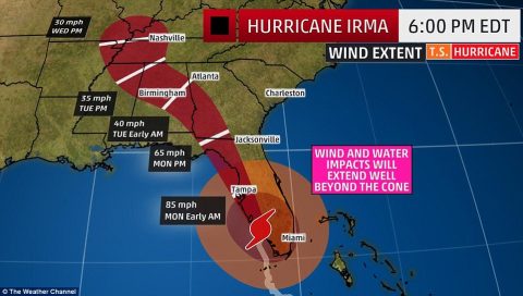
Concern is greatest for Tampa.
* Tampa is located deep to Tampa Bay facing Mexico Bay in middle Florida, U.S. and it is a commerce/industry and resort city. The city, St. Petersburg and Clearwater form a metropolitan area with the population of 2,747,272 (in 2009). This is the 19th largest area in the U.S. (Wiki)
<snip>
Tampa is located deep to cove of ria coast and the hurricane moves along the left side of Florida and goes in the direction of forward movement and wind-force is intensified.
<snip>
Tampa will go on full alert in the early hours of September 11, Monday. Tide table shows
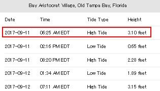
High tide at 6:30 AM,
Heavy rain, strong wind from the sea to the land, increase in sea level at the central low-pressure area of the hurricane, amplified sea level along the ria coast, high tide are likely to cause major flooding.
The date is September 11. Everything is calculated in Irma (war goddess).
—
English translation of an excerpt from the Japanese version of Weekly geo-political news and analysis – September 11, 2017 –
Hurricanes attacking the U.S. relevant to power struggle in financial world
Abnormal circumstances about the fateful crisis the U.S. faces is escalating. What I am most concerned about recently is the mover of destructive super hurricane which is presumably ‘weather warfare attack on the U.S.’
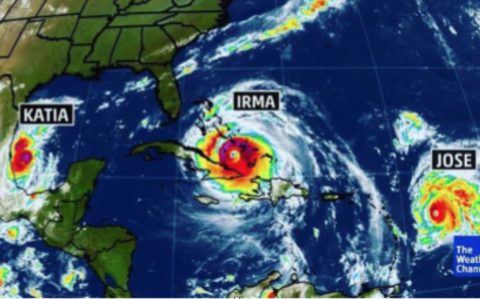
Hurricane ‘Irma’ which has developed into the most powerful hurricane (Category5) on records is directly striking Florida. Hurricane ‘Irma’ has the maximum wind speed of about 300 km/hour. The U.S. government issued the largest-scale evacuation order to more than 6,500,000 residents of the state.
Hurricane ‘Harvey’ which was reportedly “the once in 500 years” has just stricken Houston, Texas, the 4th largest city in the U.S. Furthermore, simultaneously with hurricane ‘Irma’, two more hurricanes ‘Katia’ and ‘Jose’ have been formed in the Gulf of Mexico and North Pacific Ocean.
[Hurricane Irma]
Even official propaganda news report that weather scientists hold opinion that the four hurricanes ‘Harvey,’ ‘Irma,’ ‘Jose’ and ‘Katia’ were formed simultaneously and it is “baffling.”
The observation data released on the website of the U.S. Navy shows that “unidentified electromagnetic waves” are radiated from Antarctica toward the hurricane Irma.
(The rest is omitted)
Excerpt from a Japanese article: Design of Creation Society – September 11, 2017 –
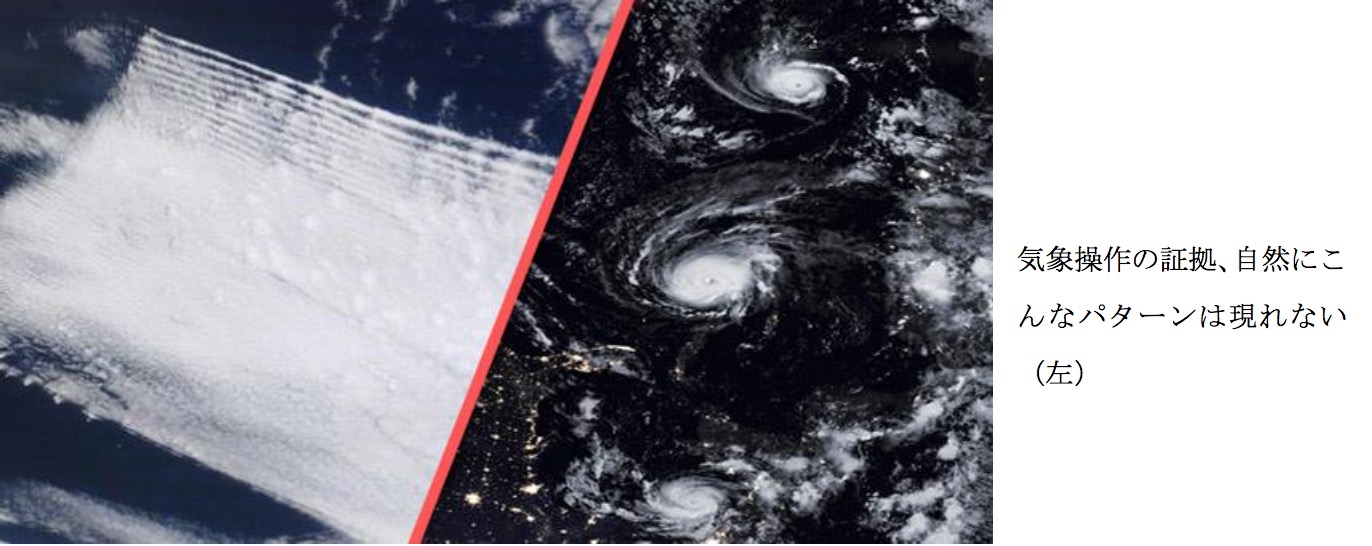
NASA Satellite Images Prove Hurricanes Are Man-Made, And More Are Coming
Source:
As Hurricane Jose is set to reach a category 5 storm following in Irma’s pathway of destruction, fresh evidence emerges from NASA satellite images that the recent record-breaking weather is actually man-made and that more is to follow.
<snip>
Now images obtained from the National Aeronautics and Space Administration orbiting satellites have shown strange anomalies in the weather that prove it is being manipulated to create deadly storms and earthquakes.
Anon reports: Patrick Roddie, an activist known for taking rain samples and proving their contamination with high levels of aluminum and other geoengineering related materials found NASA Worldview satellite pictures, that show suspicious patterns around the recent hurricanes Harvey and Irma, and the paths they follow/are about to follow.
In this video, one can see the feathery features, haze, and wave patterns commonly seen in a chemtrail sprayed and electromagnetically zapped sky, appearing around the hurricanes and their paths.
Lines of sprayed aerosols and wispy, feathery features easily recognizable as geoengineering material were spotted around the recent hurricanes.
(NASA Satellite Images Implicate Geoengineering of Hurricanes: Patrick Roddie, 1hr. 19min. video)
(The rest is omitted)
Leave a Reply